Monday, May 26, 2014

Hwy 281 Milepost 55 to 300

Today, I left my home in Pharr, TX.  Just a tidbit of trivia about Pharr, pronounced Far..... the town is named after a gentleman named Pharr who's original spelling of his last name was Farr.  The spelling of the Scottish name was changed when a scholarly member of the family who had a considerable knowledge of the Greek language substituted the Greek letter phi (in English ph) for the initial f, and since then, the last name has been spelled Pharr.

Milepost 80 (30 miles north of river (Rio Grande River), the land changes from mainly farm and crop land to ranch land, much of it untouched in years.  However in the midst of the ranch land along the way, I saw miles of sunflowers in the fields.


Milepost 118 (68 miles north of river) we go through an immigration and security checkpoint.  There is a checkpoint at the river, but then we have another one.  From the Valley to this point, many illegal immigrants get stranded and lost in the thick ranch brushland of this part of the state.  The county where this checkpoint is located have founds hundreds of dead bodies in their ranch land.  


Milepost 213 (168 miles north of river) I crossed the Nueces River, which was the original boundary between Mexico and the Texas territory.  This river runs quite close to San Antonio where the battle of the Alamo took place.  I always wondered why the Mexicans went so far north to do battle.  

Just north of this river, we really start to use the impact the natural gas and drilling has on this part of Texas.  This refinery has been here since before we moved.  Now with the discovery of the Eagle Ford shale, there is boom of growth in the towns in the area.


The Eagle Ford Shale gas formation was discovered in 2008 and is unlike many other shale formations because it has both oil and natural gas resources. Located in Southwest Texas, the Eagle Ford Shale is estimated to have 20.81 trillion cubic feet of natural gas and 3.351 billion barrels of oil. The formation ranges in depth from 5,700 to 10,200 feet and covers over 3,000 square miles.

Supporting Texas Communities

- See more at: http://www.energyfromshale.org/hydraulic-fracturing/eagle-ford-shale-gas?gclid=CLDzpr_7yr4CFYtAMgodAVYAPw#sthash.SD5anREh.dpuf.  


Milepost 225  I bought my first bag of Twizzlers....my travel food of choice!

Milepost 265   Drove through the small (but growing due to all the drilling in area) city of Pleasanton.  It bills itself as "the birthplace of the cowboys."  I wondered about that until I looked it up Wikipedia (see below)
The roots of the cattle kingdom can be traced to Atascosa County in the 1860s, which calls itself "the birthplace of the cowboys."

Milepost 265 - 270  Monsoon rains of which I have not seen the likes of in years!  Could not find a place to pull over as the ditches were flooded and finally found a country road that went down hill so that I could pull off the road.  After about 15 minutes of waiting and calling my hubby and asking, "Are they forecasting another Noah's flood for south of San Antonio?"

It did let up some so that I could get back on Hwy 281.  I was coming up to an intersection and most vehicles had there emergency flashers going.  I could see a car in the right lane and it didn't seem to be moving.  Quickly I changed lanes to the left and parked my car in an intersection.  This photo was taken after several Good Samaritans stopped to help this lady.

Milepost 300 -- Wow!  I  could not have planned that any better.... it's in downtown San Antonio.   


Texans sure like their state flag!  I think you will see more Texas state flags on display than the USA flag.  Guess that's why it should not seem abnormal that only a few years ago, our governor was talking secession.  
One of the most famous attractions in San Antonio is the RiverWalk.  It's a canal that flows through part of the town (one story below street level) and has tons of shops and restaurants.  


Here's a view from street level.

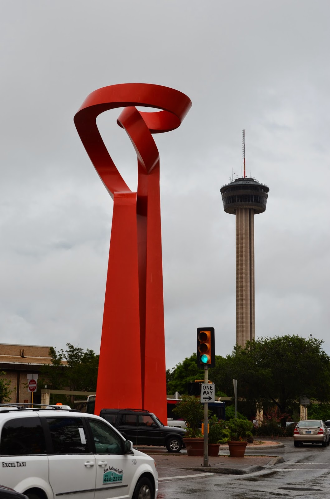
On a nearby street corner you can see a sculpture and the Hemisphere Tower that was built for the 1968 World's Fair.
There is a historic area call La Villita that is just above the RiverWalk.  The old homes and shops are still being used for selling and displaying art and crafts.  Very quaint walking area.


Sometimes the opposite of quaint is unique or bizarre.  So it is, that another famous site (since 1881) in San Antonio is the Buckhorn Saloon.   

It is truly an interesting museum, full of every kind of stuffed....fur, fin, and feather!

Many people that visit San Antonio only go to the RiverWalk and a few streets beyond that.  However, San Antonio's early settlers were Indians, Mexicans and missionaries.  There are a string of missions along  the river and most are original.  These missions were basically forts and the people lived within the walls (most 2-3 feet thick).  This protected them from invaders and provided a community to all.  These missions are about 3-5 miles apart.  The most famous mission and the furthest north mission is the Alamo.  This is where the Battle of the Alamo took place in 1836. 


The next mission south is Concepcion, which has been serving, and continues to serve Mass since 1731 and is in the best shape of the missions.


The bells in the tower of the Mission Espada have made it famous with photographers. 


The other two missions of the five are San Jose and San Juan.  Here is photo of an old door at San Juan.  I love OLD doors and window and buildings and roads.... I guess I love OLD!

San Antonio is the by far the largest community that Highway 281 goes through.  It is the fourth largest city in Texas and 25th largest city in the USA.  Lots to see, lots to do!  Until tomorrow...adios!


Saturday, May 24, 2014

Hwy 281 Milepost Zero to 55

Yesterday, I started my road trip going backwards to Brownsville to catch the start of Hwy 281.  Brownsville, the crossroads of two nations.

Brownsville is about 20 miles from the Gulf of Mexico via the Rio Grande River.  It was a different port years ago (1800's) when most ships coming up the river were no larger than a modern day yacht, probably smaller.  During the Civil War, Brownsville became a center for smuggling supplies in and out of Texas for the Confederate Army.

Ranching was the dominant industry of the region due to the abundance of land and the shortage of rainfall for crops.  There were a lot of wild horses and cattle in the area, many rounded up by Mexican and American cowboys and they drove them north from Brownsville and surrounding areas to Kansas rail heads (i.e. Chisholm Trail).  Nearly one in three cowboys were either Mexican or African American.  A few adventurous young women also made the journey, sometimes disguised as boys.  Many of the terms (lasso, lariat, mustang, chaps and bandanna) that were originally Spanish words have became everyday speech for the cowboys.

In the mid 19th century, irrigation was started in the Valley and really took hold in early 20th century.  The ranch land of the Valley has been transported to large farms growing sugar cane, cotton, sorghum, onions, and cabbages.  Below is photo of workers picking cabbage and loading onto trailers.


Field

Irrigation ditch

Farmland with Irrigation pump marked by local gang

Trailer of cabbage


Hwy 281 begins in Brownsville in a busy intersection, complete with stores, restaurants and traffic. 

For about 21 miles, the small settlements along the river come one after the other.  This same pattern occurred when the Highway 83 was built along the railroad and for 50 + miles you only notice that you have gone from one city to another by the city sign.  

Hwy 281 follows the Rio Grande River west & northwest for almost 50 miles and along the way you will see portions of the Border Wall.  The Wall will go on for a mile or two, then there are large gaps and roads going right through the area.


The local newspaper today reported that in the past week over 7000 undocumented immigrants were detained in the Valley.  That is a dramatic increase!  Also, the ranking of the countries they are coming from has Mexico as fourth, behind Central America countries.
This is a never-ending situation.

In the ranch lands north of here, many of these immigrants that do not get caught by Border Patrol, do get caught by rough elements of the terrain and heat.  They die.

This may sound morbid, but cemeteries are a photographers dream....all the color!  This cemetery along 281 is an example.  


Hwy 281 turns north about 50 miles from Brownsville into the city of Pharr.  In the city, 281 is renamed Cage Boulevard.  The below photo shows how close we live to this busy highway.  Granted it was taken with a telephoto lens, but you get the point.  We live at milepost 55.  On Monday morning, I will begin to travel north on 281 for the next 1800+ miles.  Stay tuned!


Friday, May 23, 2014

IT

IT started when I was a young girl.  What is IT?  IT is my lust, my desire to travel and be on the road.  IT is my love of looking at maps and seeing where roads go....hence my discovery that Hwy 281 goes all the way from Mexico to Canada.  IT is also my love of anything "western."  I was the child of the 50's and 60's so western TV and movies were my form of day-dreaming.

There is a vague memory of my dad showing me on maps where he had traveled as an over-the-road truck driver.  I remember being jealous when he left and I could not go with him.  In sixth grade, a series of books that were biographies of American Indians and other historical people came into my life.  The books had orange binding (funny how I remember that) and I read every one of the dozen or so we had in the school (Oak Hill) library in the Big Room.

In my late 20's, 1979, I took my first road trip with my sister, Romey.  I remember we left Wisconsin the day after my 10th high school class reunion at the Bon Ton!  Uffda!  We were both poor so we slept in the back of my Chevette!  Across South Dakota to Badlands, Mount Rushmore, Deadwood and then into Wyoming to Cody and Yellowstone National Park.  We left Yellowstone by the north entrance and we stopped at my grandmother's cousins place in Big Timber.  Heading home, we were broke and tired, but the travel bug had gotten IT's hooks into me.

The same year a book, "A Walk Across America" by Peter Jenkins was available.  I loved reading about the places he walked and people he met.  I think it was after reading his story, that I decided to take another road trip by myself.   So it was, in April, 1980, I took off.  I had some planned stops along the way, college friends in Minnesota and relatives in St. Louis, but after that it was a daily decision on what road on the map I would take.  I was still "poor," but I upgraded to a pup tent to sleep in!  I went through Arkansas (that is only time I have been in that state), Oklahoma, Texas, New Mexico, Arizona, Nevada.  I remember in Texas, I was camping in El Paso and these two young guys from Houston set up camp next to me.  I was surprised when they said they had traveled all day to get there from Houston.  What? I was used to getting through two states in a day's travel.  They informed me that the distance from Houston to El Paso is the same as between New York City and Chicago.  Out came the maps to they could prove their point.

On this trip, when I finished with my fun in Las Vegas, a decision had  to be made.....was I going to go to Colorado or California?  Both states I really wanted to see, but Colorado won out.  So I went through the Four Corners (Utah, Arizona, New Mexico and Colorado) through the Rocky Mountains to Denver and up to Loveland.  A former housemate from Minnesota had moved to Loveland, so I paid her a surprise visit.  The next day, while she was working, her friend took me up to Estes Park to see the Rocky Mountain National Park.  Even though it was a foggy day, I was hooked!  I went back to Estes the next day and found a job as waitress (I had started waiting tables before this trip to make extra travel money).  Then as luck would have it, another new hire at the restaurant needed a roommate.  Voila!  I was now working and living in Estes Park.  This is still one of my favorite places to see and be.  That summer I got out the maps again and would often explore the roads of Colorado.  By August, I was homesick and went back to Minnesota.

A couple of years later, 1982, the travel bug was making me itch like crazy again.  So when a former co-worker turned best friend, Diana, was going to move to California and told me we could use her uncle's place free of rent for the summer.... it didn't take me long to decide to hit the road for the "other" state I missed out on before.  While I was in California for over three years, I would often take time off and explore the state and go to historical places and parks.  Many of my co-workers and friends there often exclaimed, "You have seen more of California in a year than I have my whole life."

In 1986, I made another road trip from Wisconsin to Georgia.  This trip was for love!  :)  I moved down there to be with Paul, now my husband for almost 26 years.  Due to the circumstances of our long-distance relationship and having not spent more than a couple weeks time total together, it was a big risk.  But I knew that if it didn't work out, I would make the best of it and decide to stay or leave Georgia...no big deal.  I had moved across the country a couple times by now.

We lived in Georgia for over twelve years and luckily I found a travel mate in my husband, who loved to explore the roads of Georgia, Tennessee, North & South Carolina just as much  I did.  During those years, we made numerous road trips between Georgia and my family in Wisconsin.  In 1999, we moved to Wisconsin and stayed there for seven years.  This time, it was Paul that was the perpetrator of the move to Texas.  He was a Winter Texan that decided he wanted to stay.  Another move across country....to the far end of the country....seven miles from Mexico!  Here we have explored areas of Texas and we have a subscription to Texas Highways which provides lots of info on places to go and see.  We have taken Highway 281 up to Hill Country a number of times.

Another subscription I have for a couple of years now is "Cowboys and Indians."  This has re-ignited my love of the West!  Remember the trails of the western expansion?  Santa Fe, California, Oregon. I am going to be crossing these trails on this trip! Remember the Chisholm trail where cowboys took cattle from Texas to Kansas and Nebraska.  I am going to be following that trail on this trip!

A few years ago when I started thinking of retirement, I knew I wanted to travel.  One day as I was looking at the Texas map, I started following Hwy 281 and saw that it went through all of Texas.  Then I got my Road Atlas and found it went through Oklahoma, Kansas, Nebraska, South Dakota, and North Dakota to the Canadian border.   Hwy 281 starts in Brownsville which is 54.4 miles from my house in Pharr. I can see and hear the traffic on 281 (named Cage Boulevard in Pharr).  So IT's appropriate that my road trip be along Highway 281.

Now that I have given you some of road trip history, you will see that even though I am over sixty years old and could be settling-down....it ain't gonna happen!  On the road again as I let IT possess me once again!


Thursday, May 22, 2014

Decision to Drift

My last blog post, I referred to my planning process....having to decide how much time I would probably be spending at each site....(over 35 sites along Hwy 281) and how far I can drive each day.  That would allow me to make a hotel reservation in advance, as we are doing on our Northeast trip.  By reading the reports of each site in my books and/or on Trip Advisor, I was guesstimating how much time to spend at each site.  Well, what happens if a museum has enough to interest me for 2 hours instead of 1 hour?  Then I have to drive that much longer in the day to get to my hotel reservation.  Uffda!  It was really starting to stress me out.

I started thinking of my last road trip back in 1980 and how I just drifted across the states and stayed where I could find a place to set up camp with my tent.  I used Triple A books and maps at that time to determine what sites I wanted to see along the way and it worked out fine.  I did not have any time constraints then (more money constraints) and I don't really have any time constraints this time other than needing to be in NW Wisconsin by June 5.  So, I decided I'm going to drift up Hwy 281.  Each day as I'm ready to rest, I will find a hotel in the area.  That way, I can spend as little or as much time at each site as I need and want.

I really hope you will follow my blog as I am excited about this trip!  There is a Fort in every state that is near Hwy 281 that I want to see and all kinds of museums and historic houses and places.  I plan to stop every 100 miles and take photos and/or videos of the terrain so that you can see what the area looks like.  This road trip and my blog will be geared towards history as it was made in these states.

I consider this road trip as another way that I am making my own personal history.

On the road again
Goin' places that I've never been
Seein' things that I may never see again
And I can't wait to get on the road again

:)

Monday, May 19, 2014

Search Surprises

As I have mentioned before, in planning my trips, I have been reviewing 3 books; a Rand McNally map book; and now Trip Advisor.  Trip Advisor is a website that you can look up a town you want to visit and it will list hotels, restaurants, and things-to-do.  For each category, it will rank the places and things by Trip Advisor reviewers...you and me.  I have reviewed several places and I find the reviews to be helpful to read.

Since Highway 281 goes through San Antonio, I looked up that city on Trip Advisor.  Of course, I have been to San Antonio many times and thought I knew all that would be ranked as highest.  I was certainly surprised to see the #1 attraction being San Antonio Western Shooting (SAWS)!  What in the world is that?  I had never heard of it!  I even looked at my search options to make sure I had the right city...yes I did.

SAWS is a small group of "volunteers" that give you an old western shoot em' up experience.  They teach you how to hold a pistol and shotgun and how to shoot it.  The reviews (112 of 114)  were "excellent" and that is almost unheard of in Trip Advisor!  Since I want to do and see the top attractions and sites in the cities and towns I go through, I showed the website to hubby.  He has not shot a gun since his Navy days in 1969  or earlier.  He wants to do this too, so he  promised me that next time we go to San Antonio, we will reserve a time to do this!  So, sorry folks, but that is one top attraction in that city that I won't be reviewing or writing about until it's done!

Now I must figure out all the things to do and see and determine what else I can skip until next time.  Then I must figure out how much time each will take and how far I can travel that day, so I know where to reserve a hotel room.  So much to do,  so little time....to plan!  I have to start packing soon too, with the thought that I will be away from home for over two months.  What a summer I am going to have!  :)

TEST TEST

I am out in the middle of the Valley, scouting out Hwy 281 and taking photos, of course.  Thought I had better check out my laptop to make sure it works from the middle of nowhere!  ;)


WooHoo! I am able to download photos & post!  Time to get on the road again!  

Sunday, May 18, 2014

Patterns & Questions

Today, I started thinking about my upcoming solo road trip I am taking next week.  Why am I doing it? What's the purpose?  What do I hope to achieve?  How can this trip better my life or the life of someone else?  Ideally, the trip will go smoothly with a marked path and sunny skies.... like the quilt below.


But, what if it goes like the patterns in this quilt?


Even with the look of chaos to this quilt, it does have a pattern.  It reminds me of trails and paths overlapping one another.  Just like my thoughts and "ramblings" often do!  Will my path overlap others?  Will my road trip lead to me to different perspectives?


Or will my road trip have layers of perspective that may not be evident at this time, but further down the road of life?


I think that some questions will only be answered on the road, others may never be answered.  All I know is this is another step in my life journey....steps that I feel destined to take one mile at a time!